Skip to content
Android waitlistTry on iPad
Get started

Earthquakes and volcanoes: CAIE IGCSE Geography questions

CAIE IGCSE Geography past-paper questions on Earthquakes and volcanoes, June 2024, June and November 2025, March 2026, a 9–1 variant, and the 2020 and 2027 specimens, with mark schemes and examiner’s reports where available.

Paper
All papers
Exam
All years
Calculations

Loading the full question list…

122 questions

  1. Q4

    March 2026 · Paper 1 (12)

    Sources (insert) ↗
    The whole paper ↗
    1
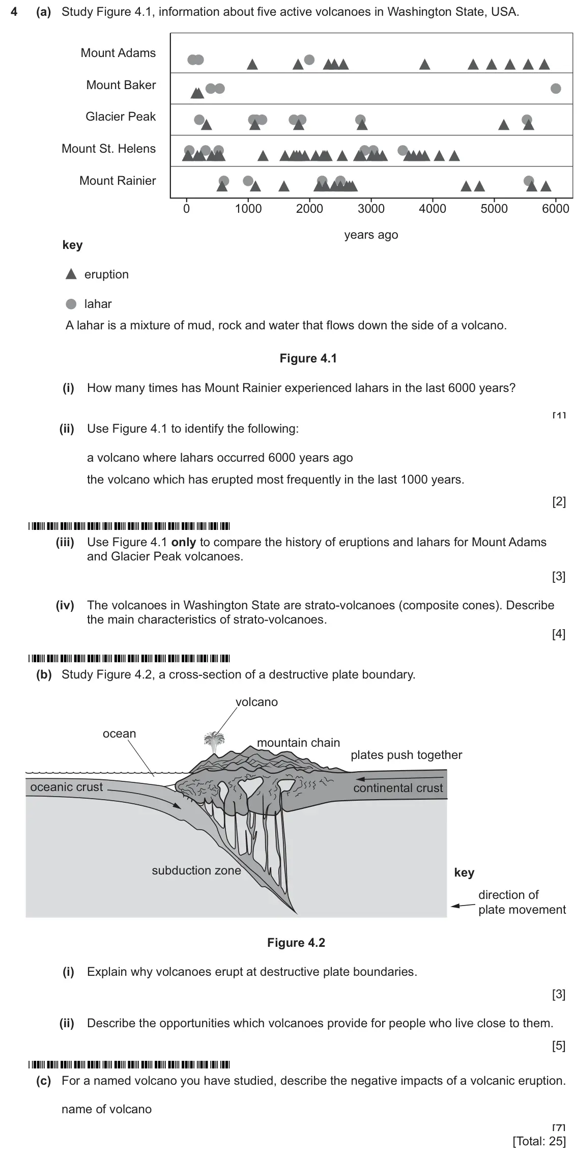
    Original question 4: (a) Study Figure 4.1, information about five active volcanoes in Washington State, USA. Mount Adams Mount Baker Glacier Peak Mount St. Helens Mount Rainier 0 10

    Loading the question…

  2. Q4

    March 2026 · Paper 2 (22)

    Sources (insert) ↗
    The whole paper ↗
    2
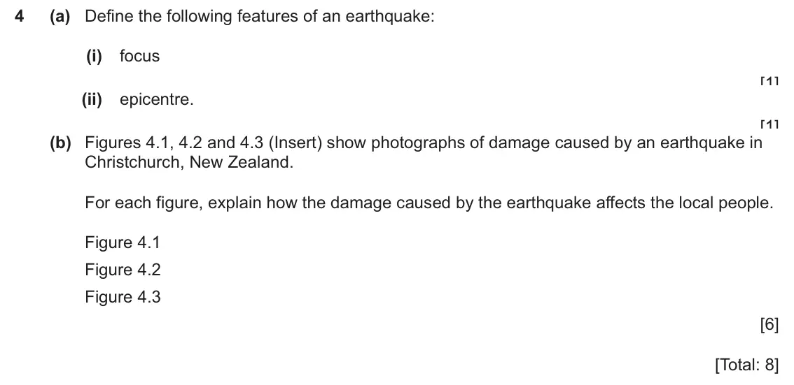
    Original question 4: (a) Define the following features of an earthquake: (i) focus [1] (ii) epicentre. [1] (b) Figures 4.1, 4.2 and 4.3 (Insert) show photographs of damage caused by

    Loading the question…

  3. Q4

    November 2025 · Paper 1 (11)

    Sources (insert) ↗
    The whole paper ↗
    3
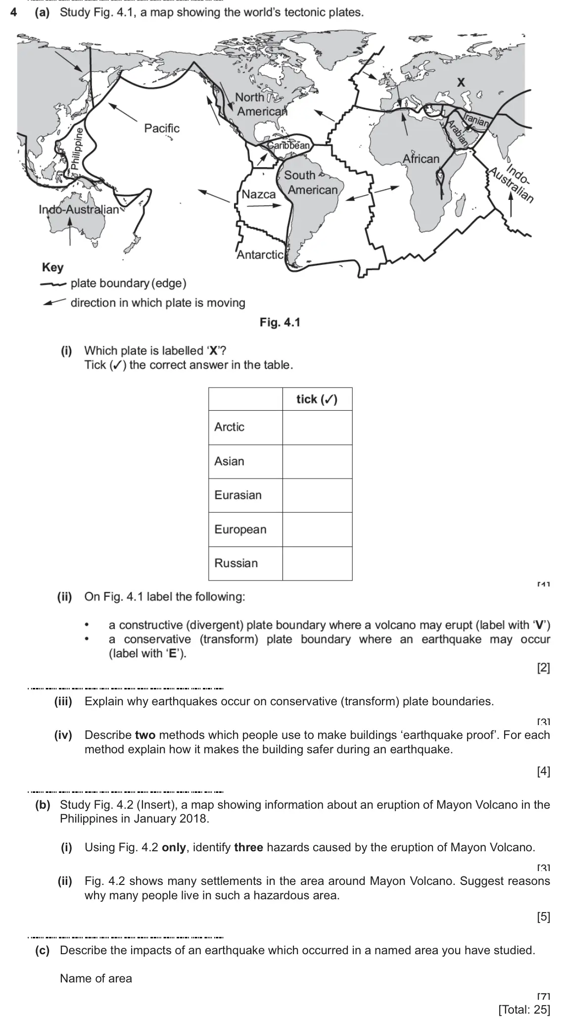
    Original question 4: (a) Study Fig. 4.1, a map showing the world's tectonic plates. North F American ranial Arabians Pacific Philippine aribbean African Australian ngo. South • Amer

    Loading the question…

  4. Q4

    November 2025 · Paper 1 (12)

    Sources (insert) ↗
    The whole paper ↗
    4
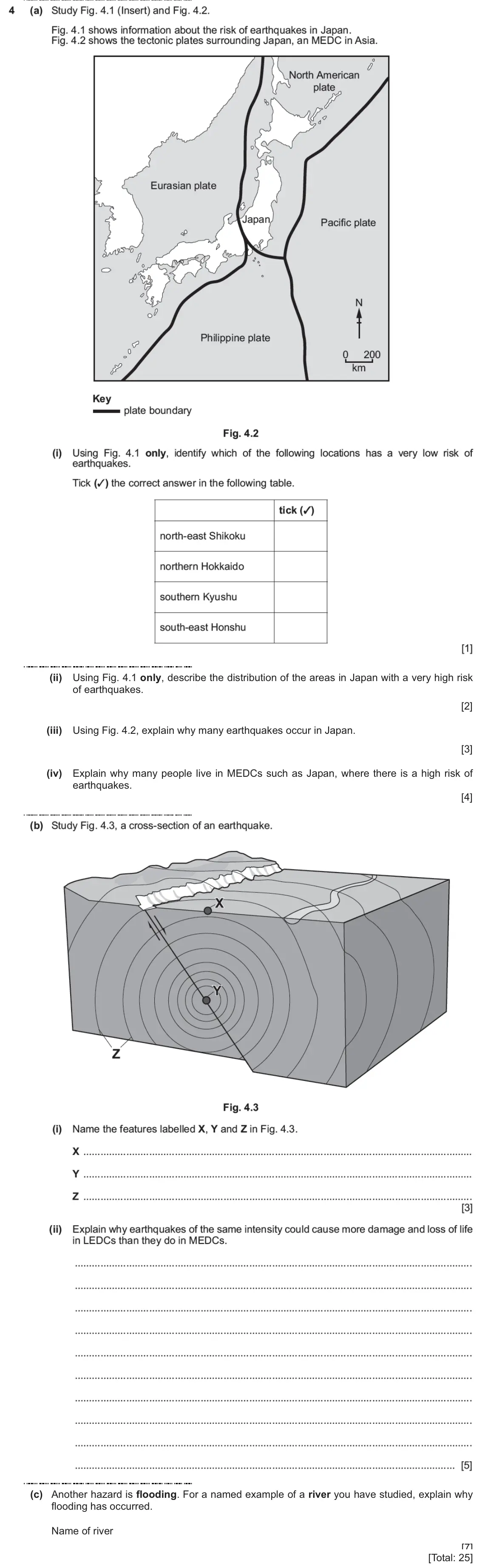
    Original question 4: (a) Study Fig. 4.1 (Insert) and Fig. 4.2. Fig. 4.1 shows information about the risk of earthquakes in Japan. Fig. 4.2 shows the tectonic plates surrounding Japa

    Loading the question…

  5. Q4

    November 2025 · Paper 1 (13)

    Sources (insert) ↗
    The whole paper ↗
    5
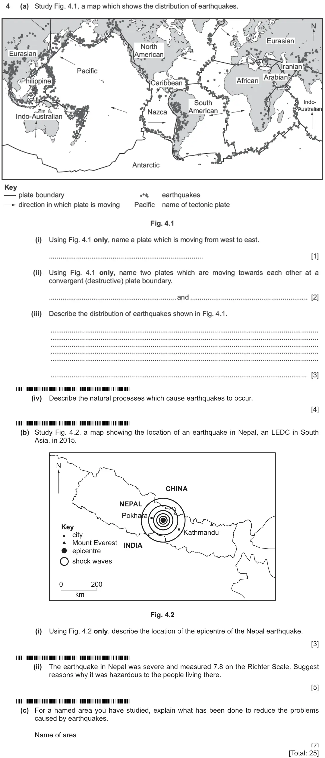
    Original question 4: (a) Study Fig. 4.1, a map which shows the distribution of earthquakes. Eurasian North Eurasian American Iranian Pacific Arabiang Philippine African *Caribbean S

    Loading the question…

  6. Q4

    November 2025 · Paper 2 (23)

    Sources (insert) ↗
    The whole paper ↗
    6
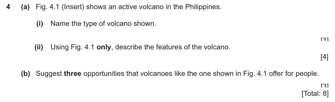
    Original question 4: (a) Fig. 4.1 (Insert) shows an active volcano in the Philippines. (i) Name the type of volcano shown. [1] (ii) Using Fig. 4.1 only, describe the features of the

    Loading the question…

  7. Q4

    June 2025 · Paper 1 (11)

    Sources (insert) ↗
    The whole paper ↗
    7
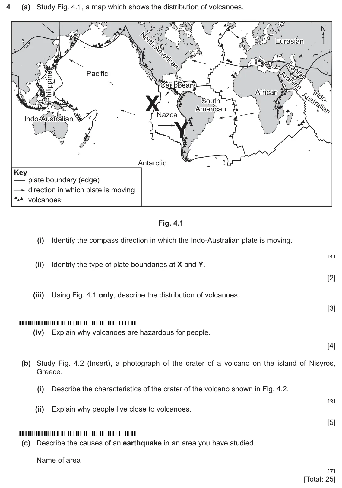
    Original question 4: (a) Study Fig. 4.1, a map which shows the distribution of volcanoes. N Eurasian Eurasian Pacific Caribbean Caribbean African African X South South American Amer

    Loading the question…

  8. Q4

    June 2025 · Paper 1 (12)

    Sources (insert) ↗
    The whole paper ↗
    8
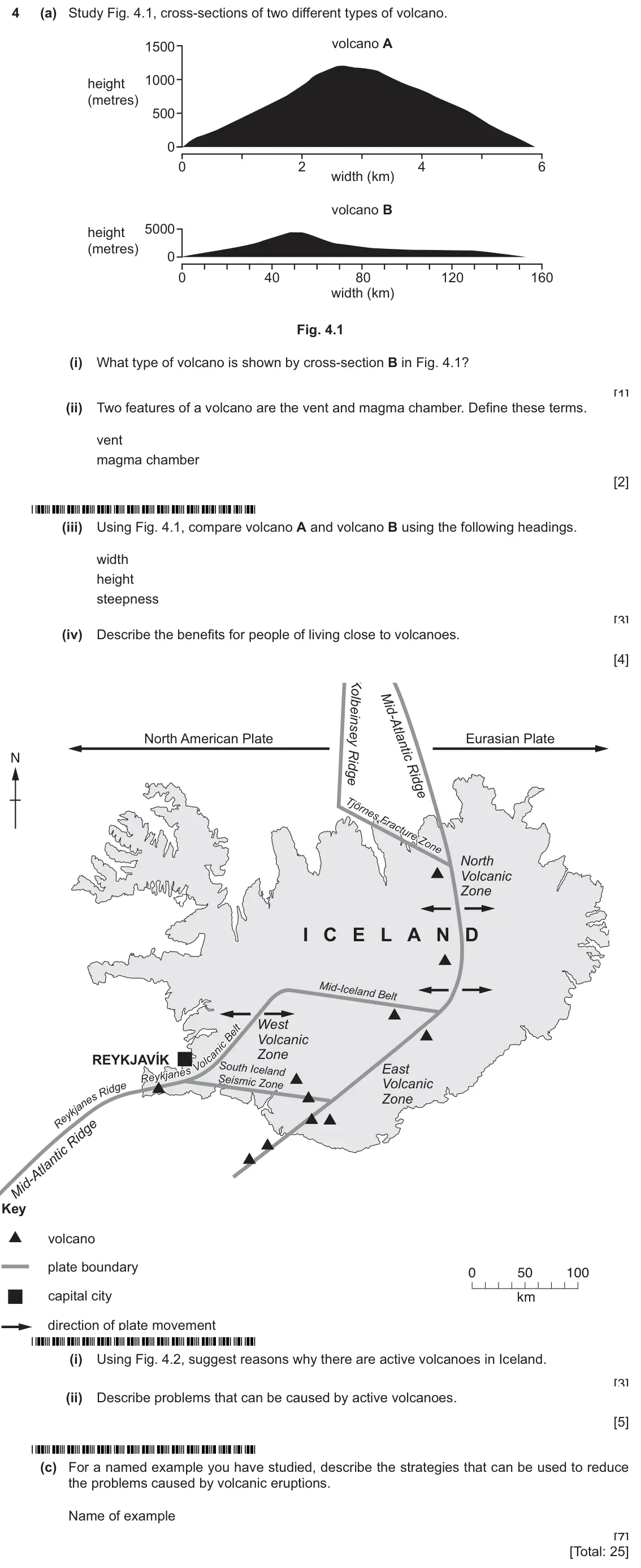
    Original question 4: (a) Study Fig. 4.1, cross-sections of two different types of volcano. volcano A 1500 1000 height (metres) 500 0 0 2 4 6 width (km) volcano B 5000 height (metres

    Loading the question…

  9. Q5

    June 2025 · Paper 2 (22)

    Sources (insert) ↗
    The whole paper ↗
    9
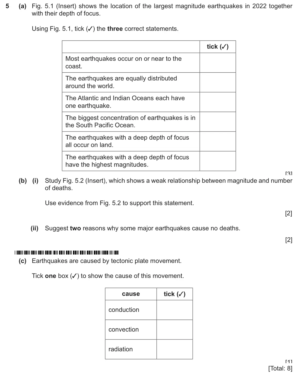
    Original question 5: (a) Fig. 5.1 (Insert) shows the location of the largest magnitude earthquakes in 2022 together with their depth of focus. Using Fig. 5.1, tick (✓) the three cor

    Loading the question…

  10. Q5

    June 2025 · Paper 2 (23)

    Sources (insert) ↗
    The whole paper ↗
    10
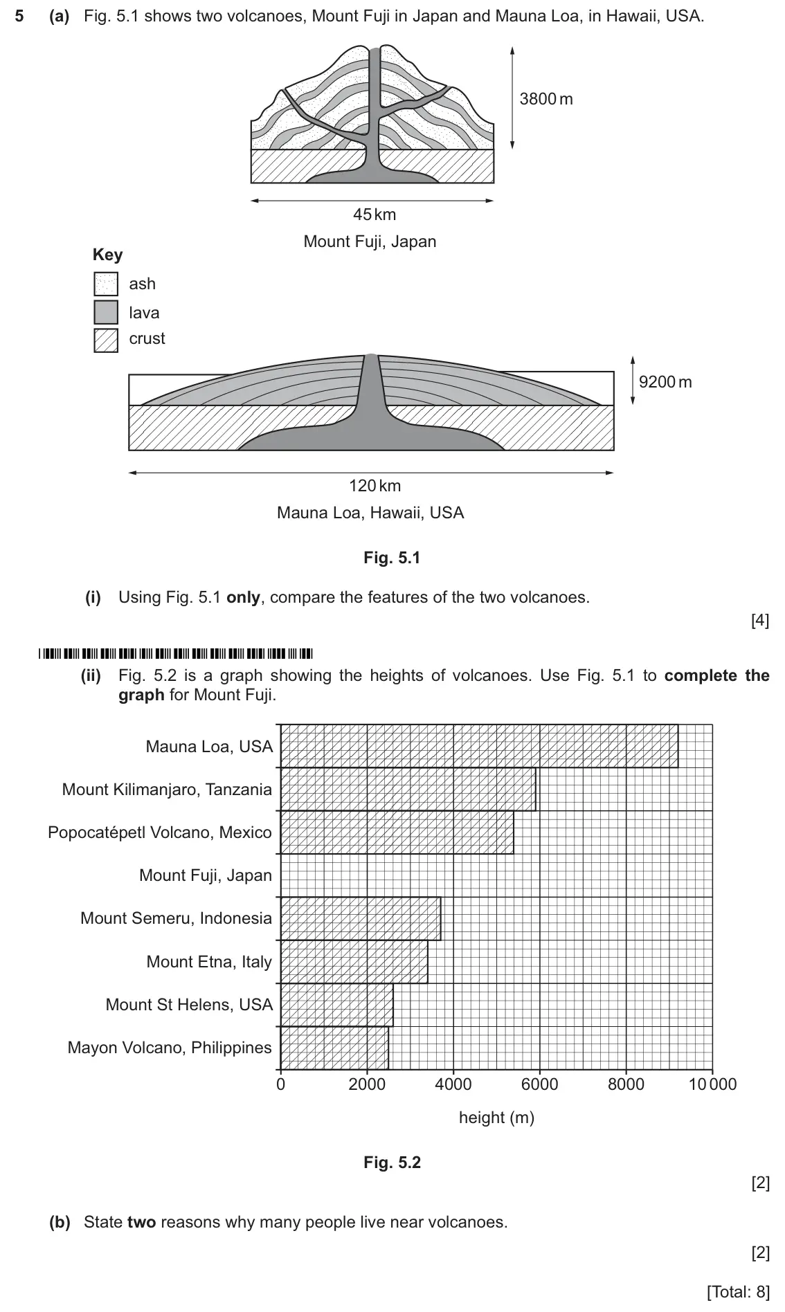
    Original question 5: (a) Fig. 5.1 shows two volcanoes, Mount Fuji in Japan and Mauna Loa, in Hawaii, USA. 3800 m 45 km Mount Fuji, Japan Key ash lava crust 9200 m 120 km Mauna Loa,

    Loading the question…

  11. Q5

    June 2024 · Paper 2

    Sources (insert) ↗
    The whole paper ↗
    11
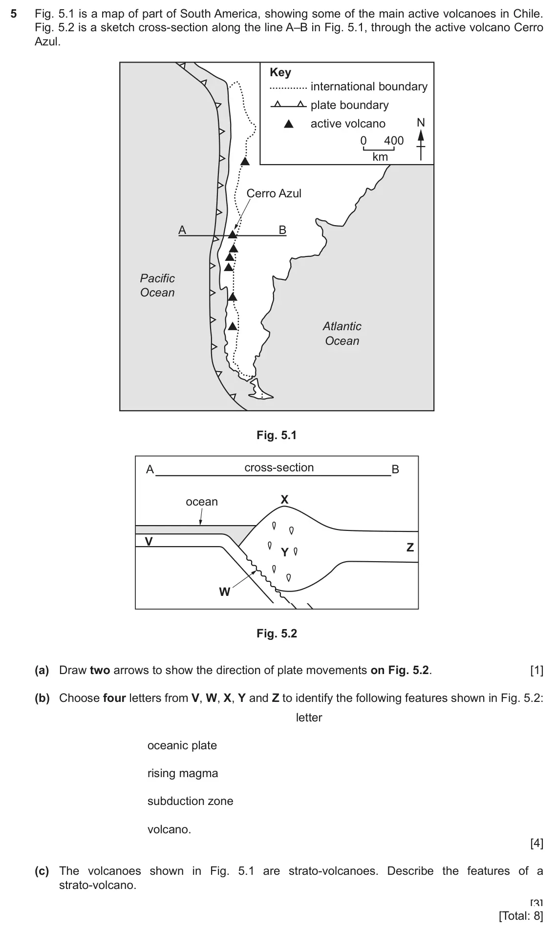
    Original question 5: Fig. 5.1 is a map of part of South America, showing some of the main active volcanoes in Chile. Fig. 5.2 is a sketch cross-section along the line A–B in Fig. 5.

    Loading the question…

  12. Q4

    June 2024 (9–1 variant) · Paper 2

    The whole paper ↗
    12
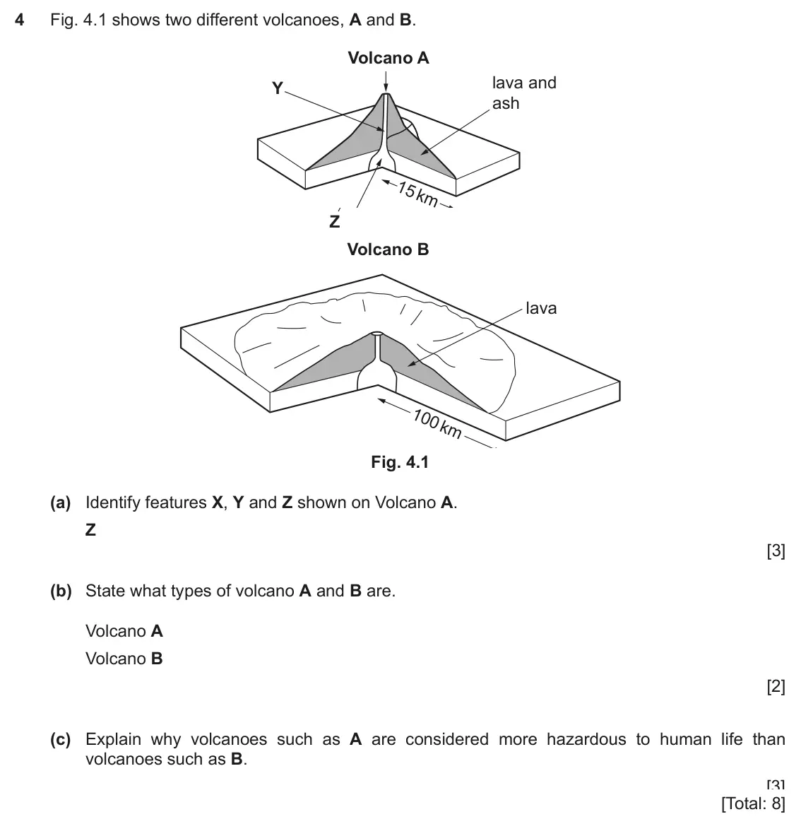
    Original question 4: Fig. 4.1 shows two different volcanoes, A and B. Volcano A X lava and Y ash Z Volcano B lava Fig. 4.1 (a) Identify features X, Y and Z shown on Volcano A. X Y Z

    Loading the question…

  13. Q1

    June 2024 (9–1 variant) · Paper 4

    Sources (insert) ↗
    The whole paper ↗
    13
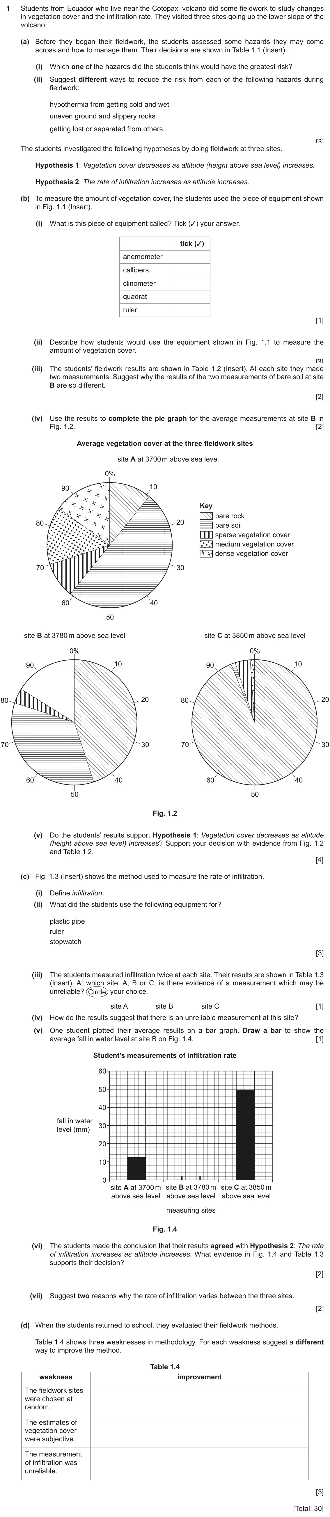
    Original question 1: Students from Ecuador who live near the Cotopaxi volcano did some fieldwork to study changes in vegetation cover and the infiltration rate. They visited three s

    Loading the question…

  14. Q5

    2020 specimen · Paper 2

    Sources (insert) ↗
    The whole paper ↗
    14
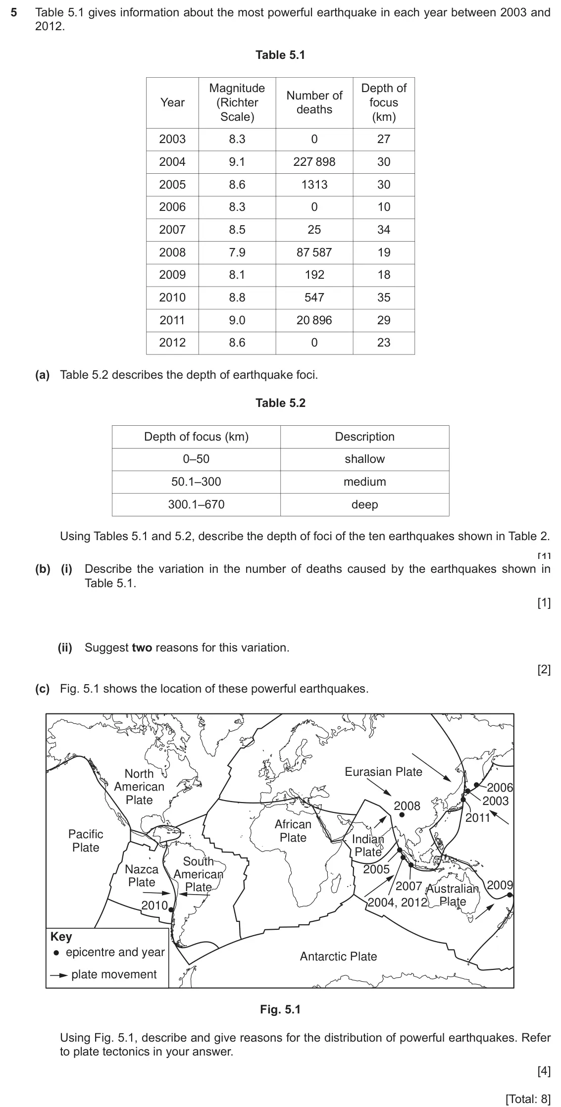
    Original question 5: Table 5.1 gives information about the most powerful earthquake in each year between 2003 and 2012. Table 5.1 Magnitude Depth of Number of Year (Richter focus de

    Loading the question…

  15. Q1

    2027 specimen · Paper 1

    Sources (insert) ↗
    The whole paper ↗
    15
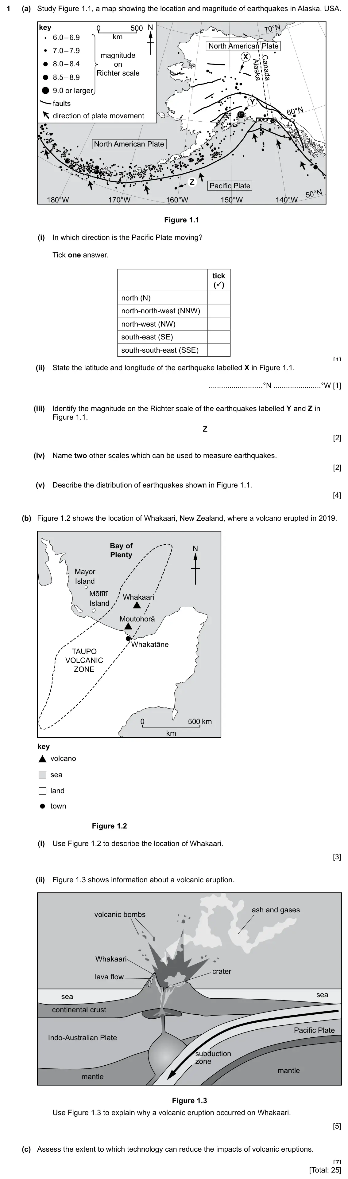
    Original question 1: (a) Study Figure 1.1, a map showing the location and magnitude of earthquakes in Alaska, USA. key 0 500 N 70°N 6.0 – 6.9 km North American Plate 7.0 – 7.9 magni

    Loading the question…

All 15 questions on Earthquakes and volcanoes, as a list
  1. March 2026, Paper 1 (12), Q4 (25 marks): (a) Study Figure 4.1, information about five active volcanoes in Washington State, USA. Mount Adams Mount Baker Glacier Peak Mount St. Helens Mount Rainier 0 10
  2. March 2026, Paper 2 (22), Q4 (8 marks): (a) Define the following features of an earthquake: (i) focus [1] (ii) epicentre. [1] (b) Figures 4.1, 4.2 and 4.3 (Insert) show photographs of damage caused by
  3. November 2025, Paper 1 (11), Q4 (25 marks): (a) Study Fig. 4.1, a map showing the world's tectonic plates. North F American ranial Arabians Pacific Philippine aribbean African Australian ngo. South • Amer
  4. November 2025, Paper 1 (12), Q4 (25 marks): (a) Study Fig. 4.1 (Insert) and Fig. 4.2. Fig. 4.1 shows information about the risk of earthquakes in Japan. Fig. 4.2 shows the tectonic plates surrounding Japa
  5. November 2025, Paper 1 (13), Q4 (25 marks): (a) Study Fig. 4.1, a map which shows the distribution of earthquakes. Eurasian North Eurasian American Iranian Pacific Arabiang Philippine African *Caribbean S
  6. November 2025, Paper 2 (23), Q4 (8 marks): (a) Fig. 4.1 (Insert) shows an active volcano in the Philippines. (i) Name the type of volcano shown. [1] (ii) Using Fig. 4.1 only, describe the features of the
  7. June 2025, Paper 1 (11), Q4 (25 marks): (a) Study Fig. 4.1, a map which shows the distribution of volcanoes. N Eurasian Eurasian Pacific Caribbean Caribbean African African X South South American Amer
  8. June 2025, Paper 1 (12), Q4 (25 marks): (a) Study Fig. 4.1, cross-sections of two different types of volcano. volcano A 1500 1000 height (metres) 500 0 0 2 4 6 width (km) volcano B 5000 height (metres
  9. June 2025, Paper 2 (22), Q5 (8 marks): (a) Fig. 5.1 (Insert) shows the location of the largest magnitude earthquakes in 2022 together with their depth of focus. Using Fig. 5.1, tick (✓) the three cor
  10. June 2025, Paper 2 (23), Q5 (8 marks): (a) Fig. 5.1 shows two volcanoes, Mount Fuji in Japan and Mauna Loa, in Hawaii, USA. 3800 m 45 km Mount Fuji, Japan Key ash lava crust 9200 m 120 km Mauna Loa,
  11. June 2024, Paper 2, Q5 (8 marks): Fig. 5.1 is a map of part of South America, showing some of the main active volcanoes in Chile. Fig. 5.2 is a sketch cross-section along the line A–B in Fig. 5.
  12. June 2024 (9–1 variant), Paper 2, Q4 (8 marks): Fig. 4.1 shows two different volcanoes, A and B. Volcano A X lava and Y ash Z Volcano B lava Fig. 4.1 (a) Identify features X, Y and Z shown on Volcano A. X Y Z
  13. June 2024 (9–1 variant), Paper 4, Q1 (30 marks): Students from Ecuador who live near the Cotopaxi volcano did some fieldwork to study changes in vegetation cover and the infiltration rate. They visited three s
  14. 2020 specimen, Paper 2, Q5 (8 marks): Table 5.1 gives information about the most powerful earthquake in each year between 2003 and 2012. Table 5.1 Magnitude Depth of Number of Year (Richter focus de
  15. 2027 specimen, Paper 1, Q1 (25 marks): (a) Study Figure 1.1, a map showing the location and magnitude of earthquakes in Alaska, USA. key 0 500 N 70°N 6.0 – 6.9 km North American Plate 7.0 – 7.9 magni

Questions, mark schemes and examiner’s reports are © Cambridge University Press & Assessment, from their published past papers. Plumi isn’t affiliated with any exam board. Want whole papers? CAIE IGCSE Geography past papers.

The Plumi iPad app also offers exam-style questions with AI feedback on your handwritten working.