Skip to content
Android waitlistTry on iPad
Get started

Rivers: CAIE IGCSE Geography questions

CAIE IGCSE Geography past-paper questions on Rivers, June 2024, June and November 2025, March 2026, a 9–1 variant, and the 2020 and 2027 specimens, with mark schemes and examiner’s reports where available.

Paper
All papers
Exam
All years
Calculations

Loading the full question list…

122 questions

  1. Q3

    March 2026 · Paper 1 (12)

    25 marksRivers
    Sources (insert) ↗
    The whole paper ↗
    1
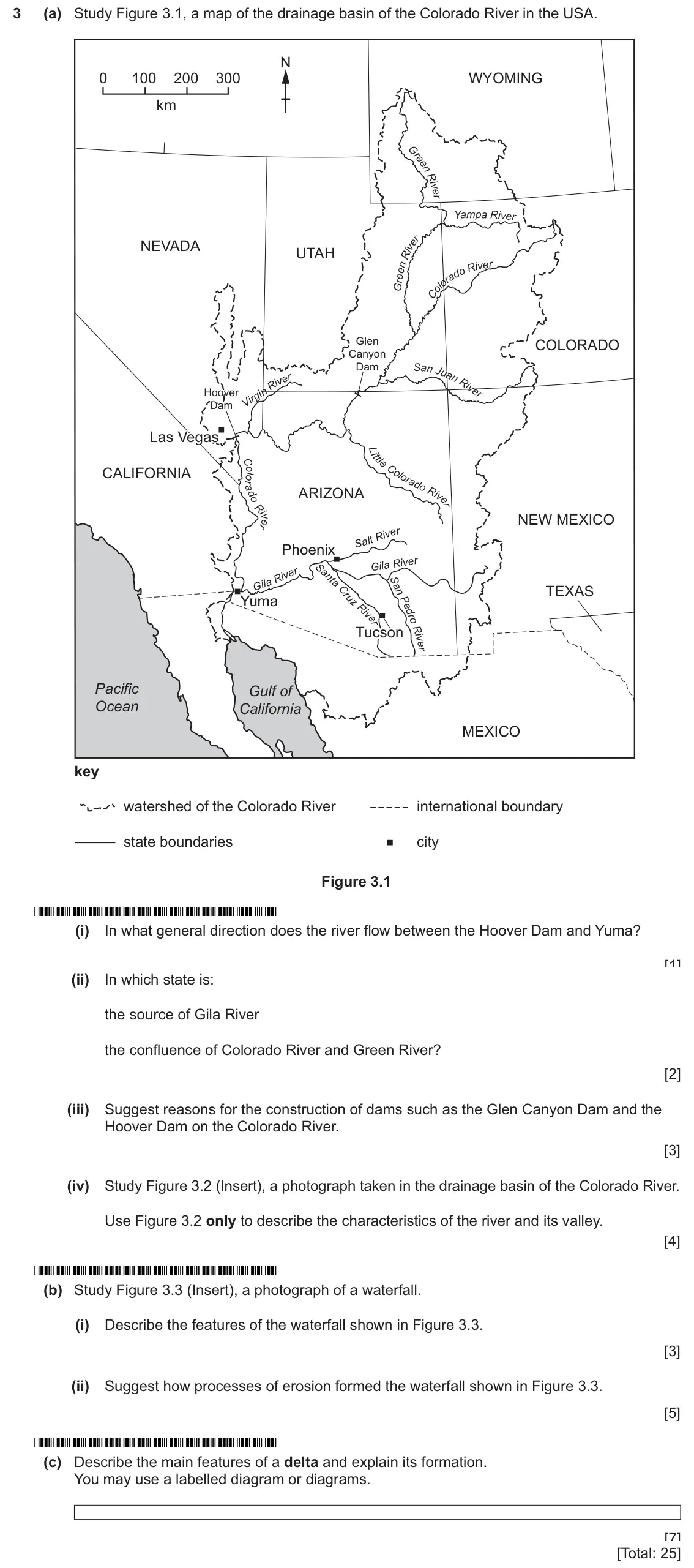
    Original question 3: (a) Study Figure 3.1, a map of the drainage basin of the Colorado River in the USA. N 0 100 200 300 WYOMING km Yam pa R ive r NEVADA UTAH R iv er Glen COLORADO

    Loading the question…

  2. Q3

    March 2026 · Paper 2 (22)

    8 marksRivers
    Sources (insert) ↗
    The whole paper ↗
    2
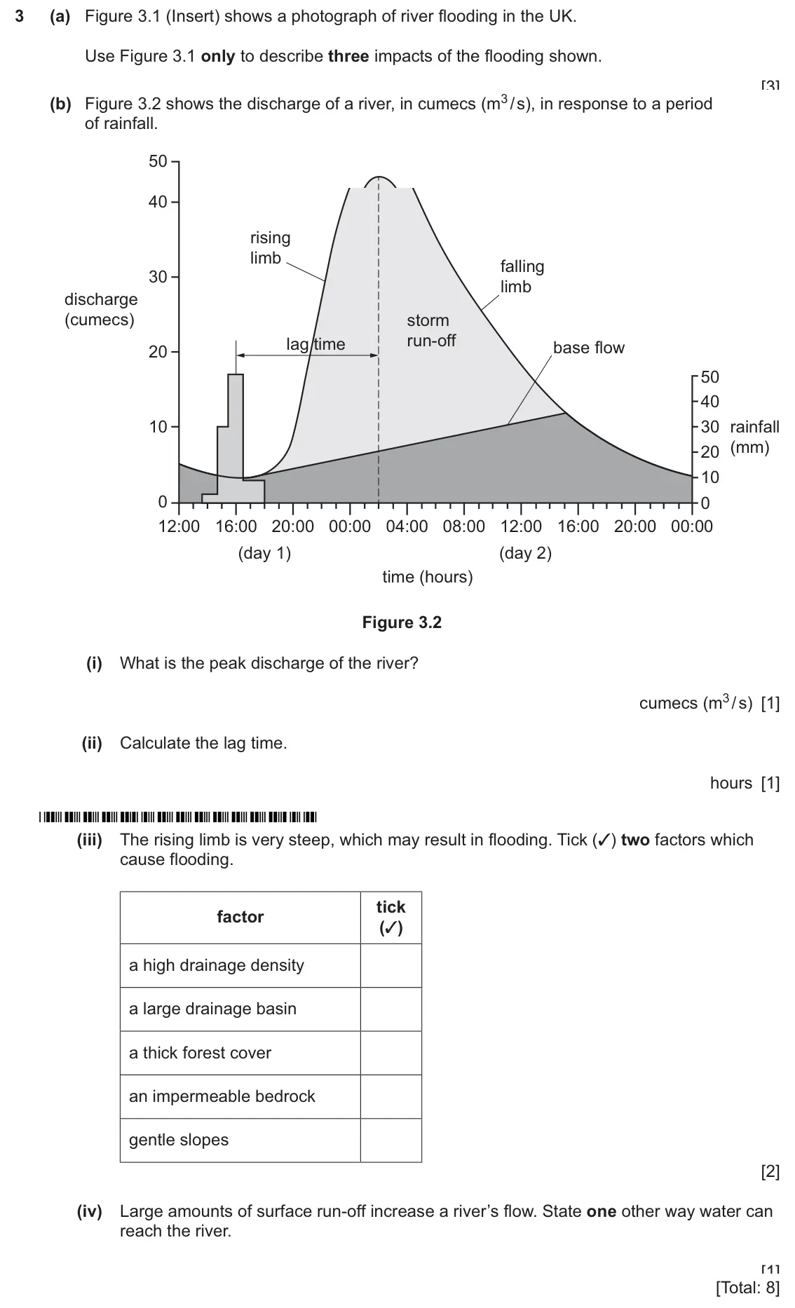
    Original question 3: (a) Figure 3.1 (Insert) shows a photograph of river flooding in the UK. Use Figure 3.1 only to describe three impacts of the flooding shown. 1 2 3 [3] (b) Figur

    Loading the question…

  3. Q3

    November 2025 · Paper 2 (21)

    Sources (insert) ↗
    The whole paper ↗
    3
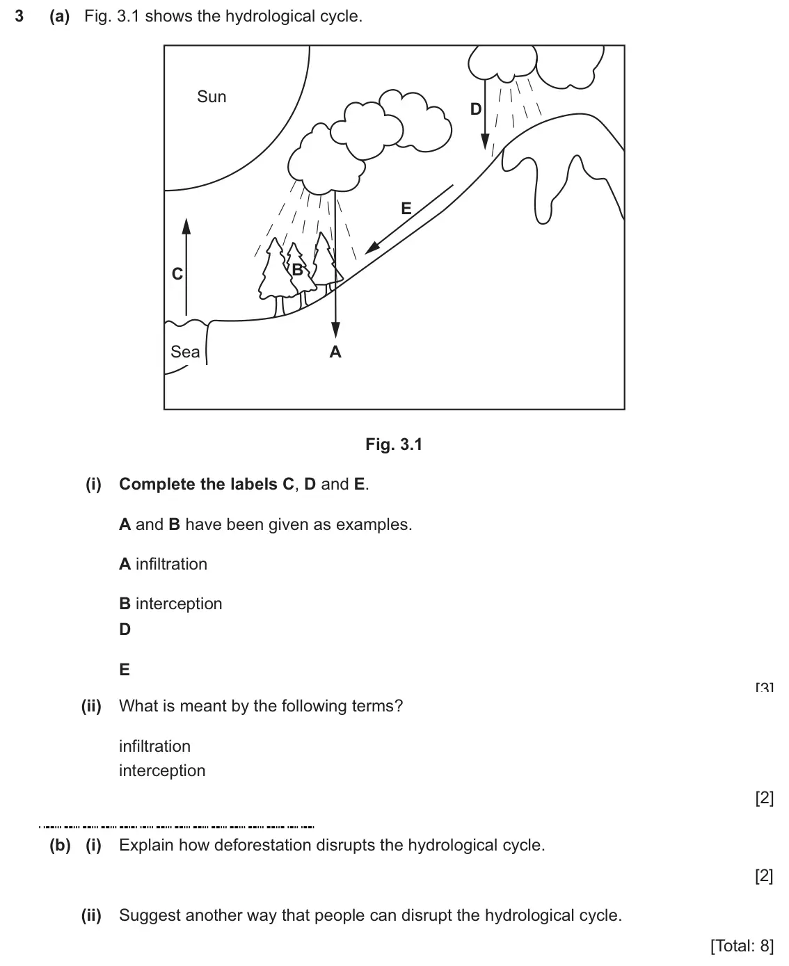
    Original question 3: (a) Fig. 3.1 shows the hydrological cycle. Sun D E B C Sea A Fig. 3.1 (i) Complete the labels C, D and E. A and B have been given as examples. A infiltration B

    Loading the question…

  4. Q2

    November 2025 · Paper 4 (43)

    Sources (insert) ↗
    The whole paper ↗
    4
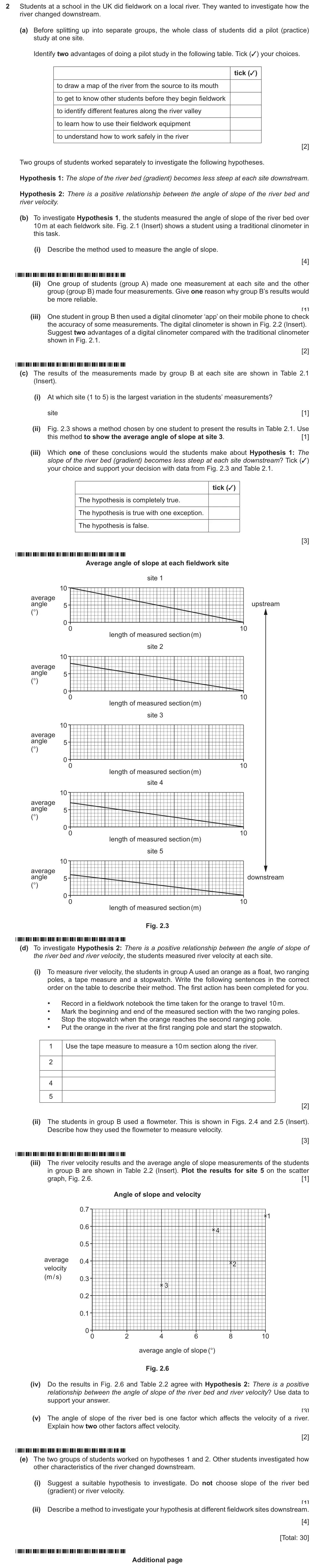
    Original question 2: Students at a school in the UK did fieldwork on a local river. They wanted to investigate how the river changed downstream. (a) Before splitting up into separat

    Loading the question…

  5. Q3

    June 2025 · Paper 2 (23)

    8 marksRivers
    Sources (insert) ↗
    The whole paper ↗
    5
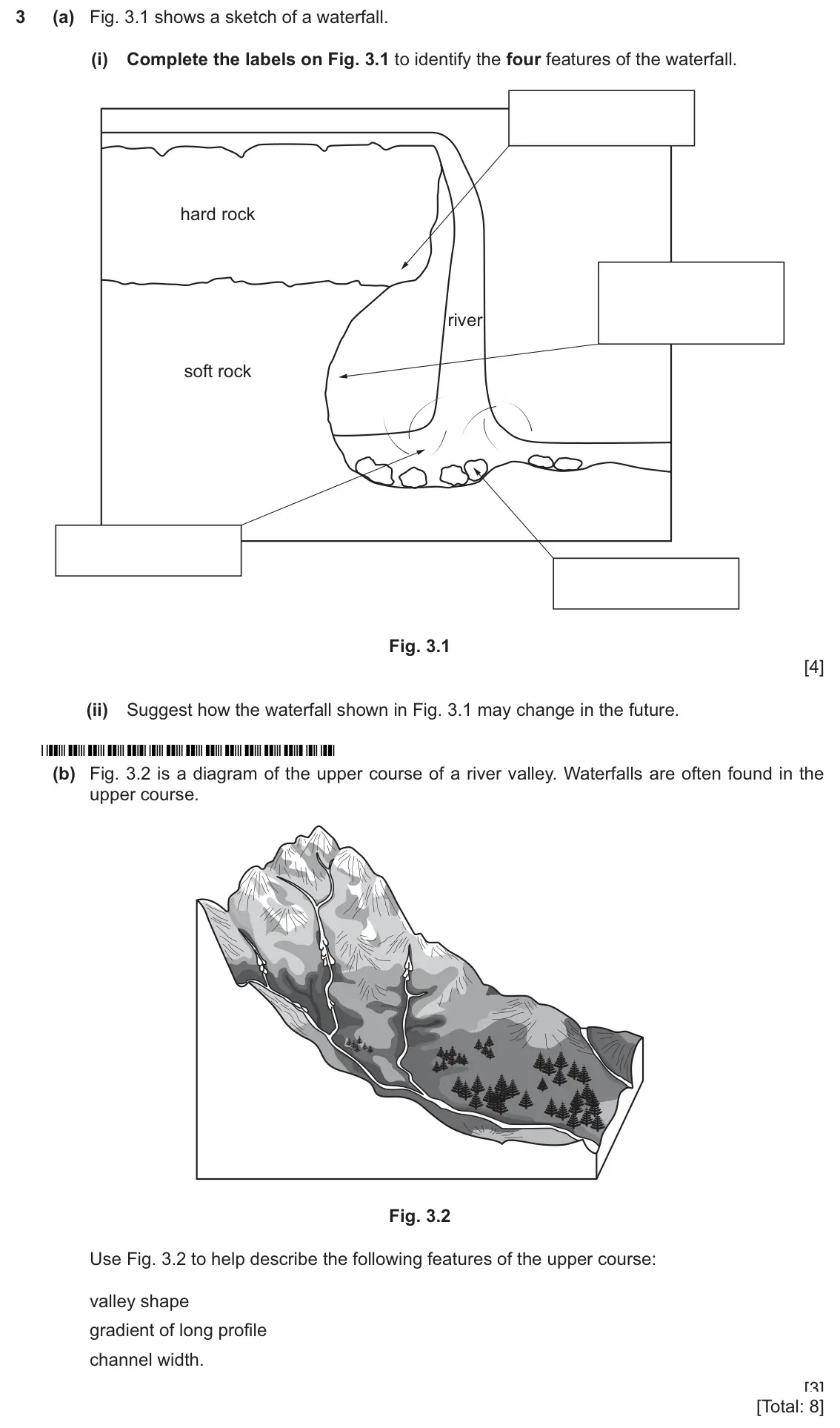
    Original question 3: (a) Fig. 3.1 shows a sketch of a waterfall. (i) Complete the labels on Fig. 3.1 to identify the four features of the waterfall. hard rock river soft rock Fig. 3

    Loading the question…

  6. Q4

    June 2024 · Paper 1

    25 marksRivers
    Sources (insert) ↗
    The whole paper ↗
    6
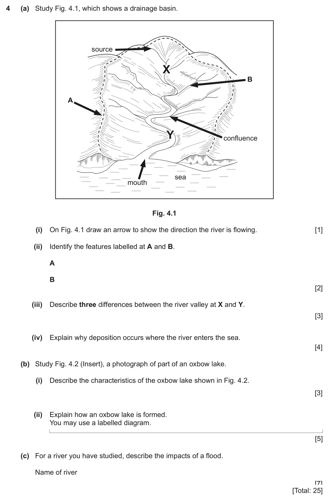
    Original question 4: (a) Study Fig. 4.1, which shows a drainage basin. source X B A Y confluence sea mouth Fig. 4.1 (i) On Fig. 4.1 draw an arrow to show the direction the river is

    Loading the question…

  7. Q4

    June 2024 (9–1 variant) · Paper 1

    25 marksRivers
    Sources (insert) ↗
    The whole paper ↗
    7
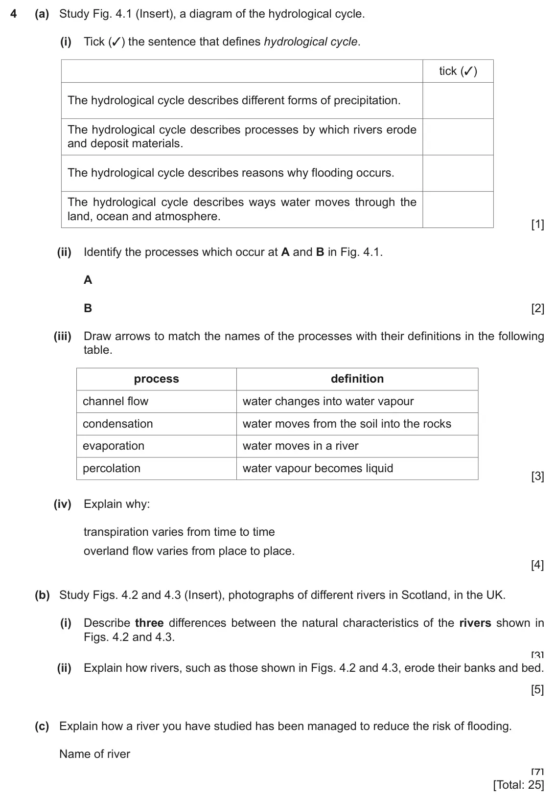
    Original question 4: (a) Study Fig. 4.1 (Insert), a diagram of the hydrological cycle. (i) Tick (3) the sentence that defines hydrological cycle. tick (3) The hydrological cycle des

    Loading the question…

  8. Q1

    2020 specimen · Paper 2

    Sources (insert) ↗
    The whole paper ↗
    8
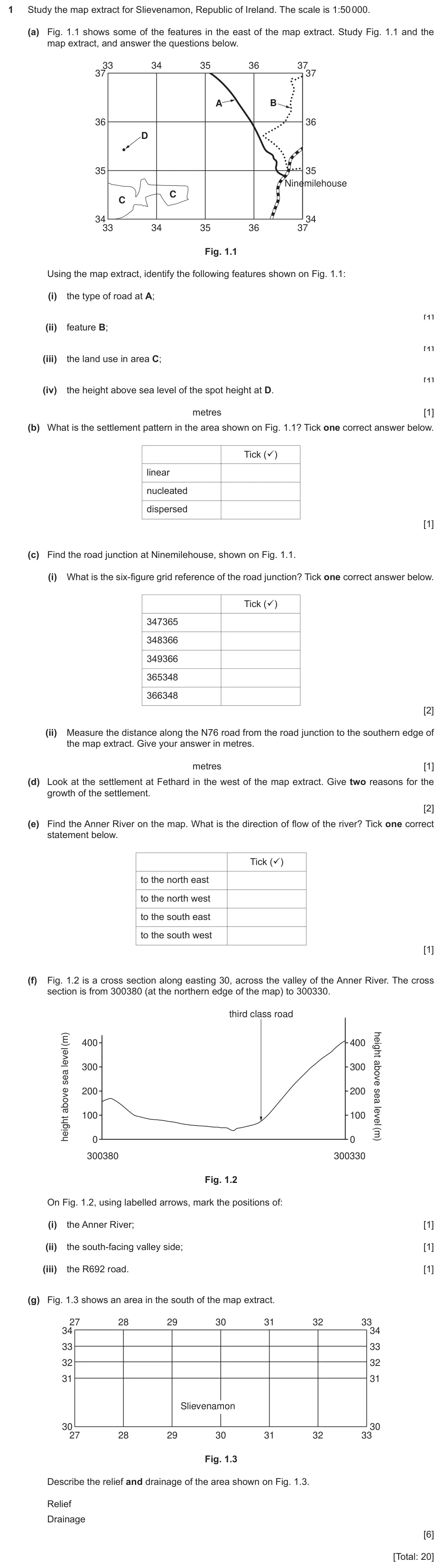
    Original question 1: Study the map extract for Slievenamon, Republic of Ireland. The scale is 1:50 000. (a) Fig. 1.1 shows some of the features in the east of the map extract. Study

    Loading the question…

  9. Q1

    2020 specimen · Paper 4

    Sources (insert) ↗
    The whole paper ↗
    9
    Original question 1: Students in Portugal went to six sites along a local river to do a fieldwork investigation on changes in the river channel downstream. The river which they stud

    Loading the question…

All 9 questions on Rivers, as a list
  1. March 2026, Paper 1 (12), Q3 (25 marks): (a) Study Figure 3.1, a map of the drainage basin of the Colorado River in the USA. N 0 100 200 300 WYOMING km Yam pa R ive r NEVADA UTAH R iv er Glen COLORADO
  2. March 2026, Paper 2 (22), Q3 (8 marks): (a) Figure 3.1 (Insert) shows a photograph of river flooding in the UK. Use Figure 3.1 only to describe three impacts of the flooding shown. 1 2 3 [3] (b) Figur
  3. November 2025, Paper 2 (21), Q3 (8 marks): (a) Fig. 3.1 shows the hydrological cycle. Sun D E B C Sea A Fig. 3.1 (i) Complete the labels C, D and E. A and B have been given as examples. A infiltration B
  4. November 2025, Paper 4 (43), Q2 (30 marks): Students at a school in the UK did fieldwork on a local river. They wanted to investigate how the river changed downstream. (a) Before splitting up into separat
  5. June 2025, Paper 2 (23), Q3 (8 marks): (a) Fig. 3.1 shows a sketch of a waterfall. (i) Complete the labels on Fig. 3.1 to identify the four features of the waterfall. hard rock river soft rock Fig. 3
  6. June 2024, Paper 1, Q4 (25 marks): (a) Study Fig. 4.1, which shows a drainage basin. source X B A Y confluence sea mouth Fig. 4.1 (i) On Fig. 4.1 draw an arrow to show the direction the river is
  7. June 2024 (9–1 variant), Paper 1, Q4 (25 marks): (a) Study Fig. 4.1 (Insert), a diagram of the hydrological cycle. (i) Tick (3) the sentence that defines hydrological cycle. tick (3) The hydrological cycle des
  8. 2020 specimen, Paper 2, Q1 (20 marks): Study the map extract for Slievenamon, Republic of Ireland. The scale is 1:50 000. (a) Fig. 1.1 shows some of the features in the east of the map extract. Study
  9. 2020 specimen, Paper 4, Q1 (30 marks): Students in Portugal went to six sites along a local river to do a fieldwork investigation on changes in the river channel downstream. The river which they stud

Questions, mark schemes and examiner’s reports are © Cambridge University Press & Assessment, from their published past papers. Plumi isn’t affiliated with any exam board. Want whole papers? CAIE IGCSE Geography past papers.

The Plumi iPad app also offers exam-style questions with AI feedback on your handwritten working.