 plumi
Investigating coastal landscapes: Edexcel GCSE Geography A questions
Edexcel GCSE Geography A past-paper questions on Investigating coastal landscapes, 2018–2025, with mark schemes and examiner’s reports where available.
Paper
All papers
Exam
All years
Calculations
Loading the full question list…
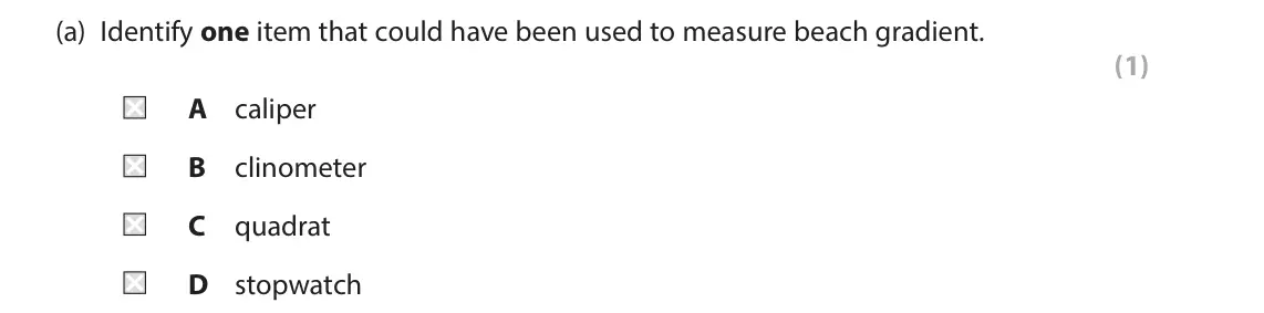
Q2(a)
The whole paper ↗ (Total for Question 2 is 1 mark)
Q2(b)
The whole paper ↗(Total for Question 2 is 1 mark)
Q2(c)(i)
The whole paper ↗(Total for Question 2 is 2 marks)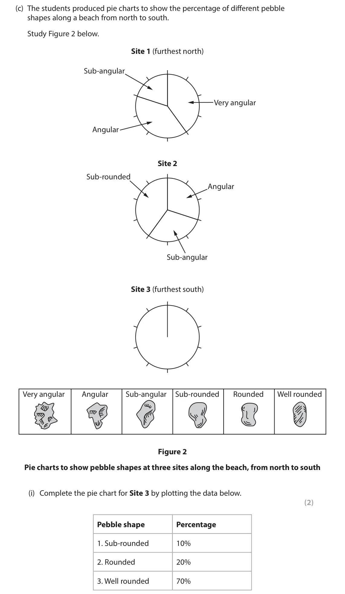
Q2(c)(ii)
The whole paper ↗(Total for Question 2 is 2 marks)
Q2(d)(i)
The whole paper ↗(Total for Question 2 is 2 marks)
Q2(d)(ii)
The whole paper ↗(Total for Question 2 is 2 marks)
Q2(e)
The whole paper ↗(Total for Question 2 is 8 marks)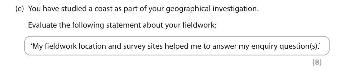
Q2(a)(i)
The whole paper ↗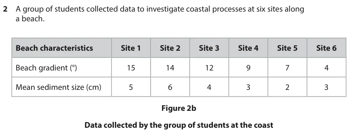 (Total for Question 2 is 2 marks)

Q2(a)(ii)
The whole paper ↗(Total for Question 2 is 2 marks)
Q2(b)(i)
The whole paper ↗(Total for Question 2 is 2 marks)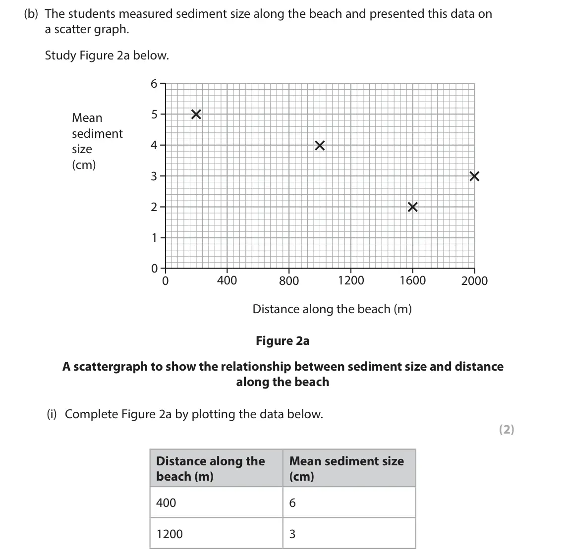
Q2(b)(ii)
The whole paper ↗(Total for Question 2 is 2 marks)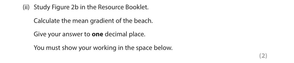
Q2(b)(iii)
The whole paper ↗(Total for Question 2 is 2 marks)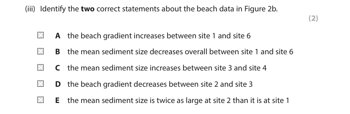
Q2(c)
The whole paper ↗(Total for Question 2 is 8 marks)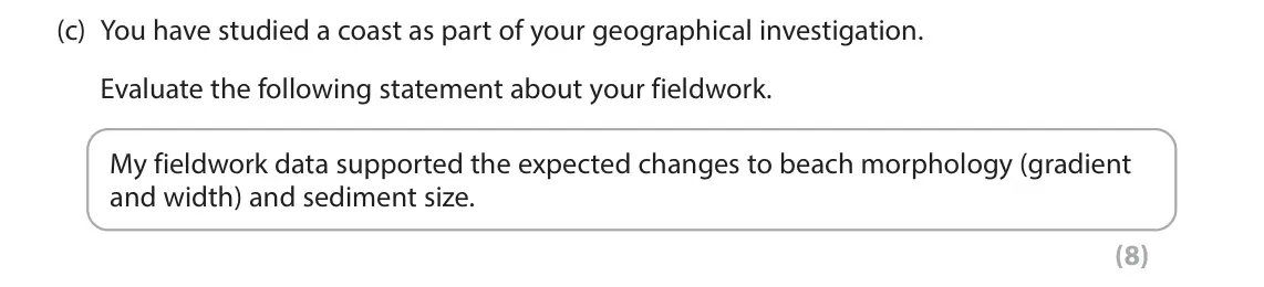
Q2(a)
The whole paper ↗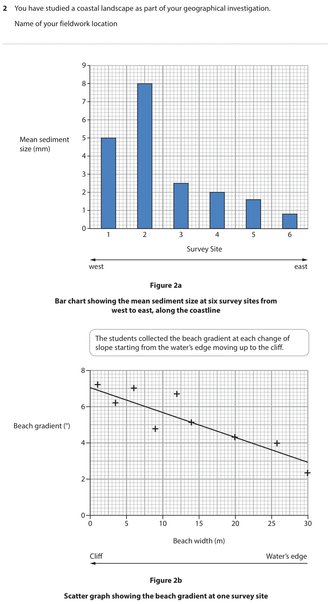 (Total for Question 2 is 2 marks)

Q2(b)
The whole paper ↗(Total for Question 2 is 2 marks)
Q2(c)
The whole paper ↗(Total for Question 2 is 2 marks)
Q2(d)
The whole paper ↗(Total for Question 2 is 4 marks)
Q2(e)
The whole paper ↗(Total for Question 2 is 8 marks)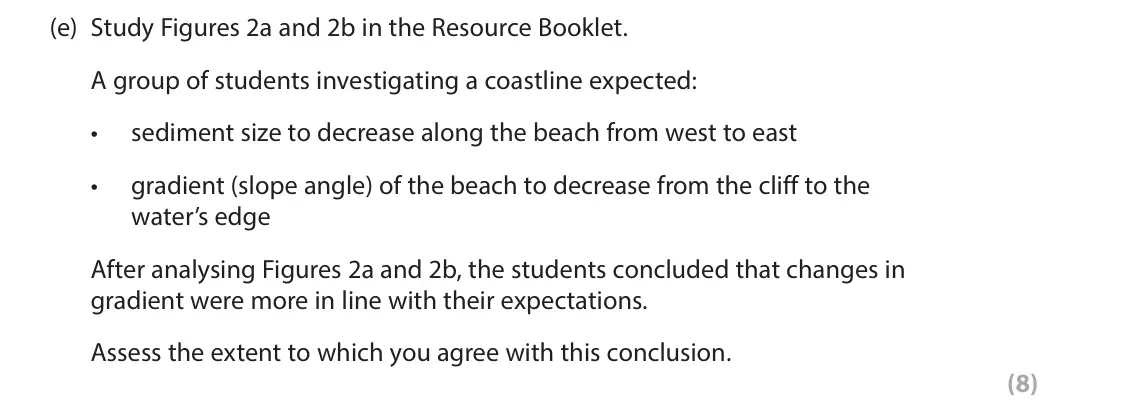
Q2(a)
The whole paper ↗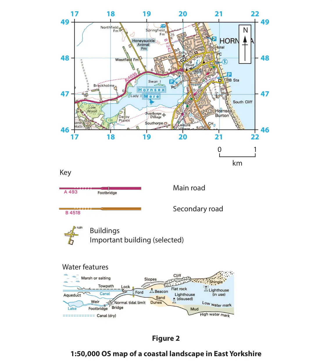 (Total for Question 2 is 2 marks)

Q2(b)
The whole paper ↗(Total for Question 2 is 8 marks)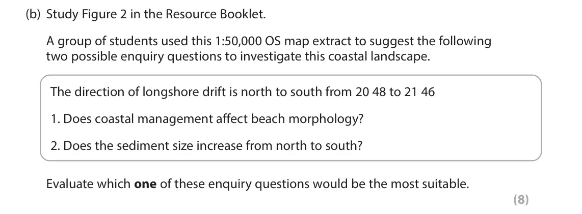
All 40 questions on Investigating coastal landscapes, as a list
- June 2025, Paper 3, Q2(a) (1 mark): Identify one item that could have been used to measure beach gradient. (1) A caliper B clinometer C quadrat D stopwatch 2 A group of students collected data to
- June 2025, Paper 3, Q2(b) (1 mark): Name the correct unit of measurement for beach gradient. (1) 2 A group of students collected data to investigate coastal processes along a section of a coast. T
- June 2025, Paper 3, Q2(c)(i) (2 marks): Complete the pie chart for Site 3 by plotting the data below. (2) Pebble shape Percentage 1. Sub-rounded 10% 2. Rounded 20% 3. Well rounded 70% 2 A group of stu
- June 2025, Paper 3, Q2(c)(ii) (2 marks): Suggest one conclusion the students could make about the changes in pebble shape shown in Figure 2. (2) 2 A group of students collected data to investigate coas
- June 2025, Paper 3, Q2(d)(i) (2 marks): Describe one fieldwork method that could have been used by the students to measure beach width from cliff to water’s edge. (2) 2 A group of students collected d
- June 2025, Paper 3, Q2(d)(ii) (2 marks): Suggest one way this method to measure beach width might not have been accurate. (2) 2 A group of students collected data to investigate coastal processes along
- June 2025, Paper 3, Q2(e) (8 marks): You have studied a coast as part of your geographical investigation. Evaluate the following statement about your fieldwork: ‘My fieldwork location and survey si
- June 2024, Paper 3, Q2(a)(i) (2 marks): Describe one fieldwork method that could have been used by the students to measure sediment size. (2) 2 A group of students collected data to investigate coasta
- June 2024, Paper 3, Q2(a)(ii) (2 marks): Explain one disadvantage of using this fieldwork method. (2) 2 A group of students collected data to investigate coastal processes at six sites along a beach. B
- June 2024, Paper 3, Q2(b)(i) (2 marks): Complete Figure 2a by plotting the data below. (2) Distance along the Mean sediment size beach (m) (cm) 400 6 1200 3 2 A group of students collected data to inv
- June 2024, Paper 3, Q2(b)(ii) (2 marks): Study Figure 2b in the Resource Booklet. Calculate the mean gradient of the beach. Give your answer to one decimal place. You must show your working in the spac
- June 2024, Paper 3, Q2(b)(iii) (2 marks): Identify the two correct statements about the beach data in Figure 2b. (2) A the beach gradient increases between site 1 and site 6 B the mean sediment size dec
- June 2024, Paper 3, Q2(c) (8 marks): You have studied a coast as part of your geographical investigation. Evaluate the following statement about your fieldwork. My fieldwork data supported the expe
- June 2023, Paper 3, Q2(a) (2 marks): Explain one advantage of a sampling strategy you used in your geographical investigation. (2) 2 You have studied a coastal landscape as part of your geographica
- June 2023, Paper 3, Q2(b) (2 marks): Explain one risk you considered before carrying out the data collection at your chosen location. (2) 2 You have studied a coastal landscape as part of your geog
- June 2023, Paper 3, Q2(c) (2 marks): Explain one way your investigation helped you understand how coastal processes affect people. (2) 2 You have studied a coastal landscape as part of your geograp
- June 2023, Paper 3, Q2(d) (4 marks): Explain two ways you tried to make sure that your data collection methods were accurate. (4) 2 You have studied a coastal landscape as part of your geographical
- June 2023, Paper 3, Q2(e) (8 marks): Study Figures 2a and 2b in the Resource Booklet. A group of students investigating a coastline expected: • sediment size to decrease along the beach from west t
- June 2022, Paper 3, Q2(a) (2 marks): Study Figure 2 in the Resource Booklet. Describe one fieldwork method the students could have used to collect data to investigate this coastal landscape. (2) 17
- June 2022, Paper 3, Q2(b) (8 marks): Study Figure 2 in the Resource Booklet. A group of students used this 1:50,000 OS map extract to suggest the following two possible enquiry questions to investi
- November 2021, Paper 3, Q2(a) (1 mark): Study Figure 2a below. Figure 2a One of the sites chosen by the students State one fieldwork method the students may have used at this site. (1) 2 A group of st
- November 2021, Paper 3, Q2(b)(i) (2 marks): Complete Figure 2b by plotting the data below. (2) Distance along the beach (m) Mean sediment size (cm) 80 10.4 140 5.6 2 A group of students collected data to
- November 2021, Paper 3, Q2(b)(ii) (4 marks): Explain two possible reasons for the anomaly shown at X in Figure 2b. (4) 2 A group of students collected data to investigate changes along a coast.
- November 2021, Paper 3, Q2(b)(iii) (3 marks): Suggest one way students could have used a geology map to investigate this beach. (3) 2 A group of students collected data to investigate changes along a coast.
- November 2020, Paper 3, Q2(a)(i) (2 marks): Describe one fieldwork method that could be used by the students to measure beach gradient. (2) 2 A group of students collected data to investigate coastal proc
- November 2020, Paper 3, Q2(a)(ii) (2 marks): Explain one disadvantage of using this data collection method. (2) 2 A group of students collected data to investigate coastal processes at five sites along a c
- November 2020, Paper 3, Q2(b)(i) (2 marks): Calculate the mean sediment size. Give your answer to one decimal place. You must show your working in the space below. (2) 2 A group of students collected data
- November 2020, Paper 3, Q2(b)(ii) (2 marks): Explain one conclusion that could be drawn from the data in Figure 2b. (2) 2 A group of students collected data to investigate coastal processes at five sites a
- November 2020, Paper 3, Q2(c) (2 marks): The students measured sediment size at each site and presented data in a bar chart. Study Figure 2c below. 10 9 8 7 6 5 4 3 2 1 0 Site 1 Site 2 Site 3 Site 4 Si
- November 2020, Paper 3, Q2(d) (8 marks): You have studied a coast as part of your geographical investigation. Evaluate the effectiveness of the different techniques used to present your fieldwork data.
- June 2019, Paper 3, Q2(a)(i) (2 marks): Explain one advantage of a qualitative fieldwork method you used. (2) What was measured? How was it measured? What were the problems? Gradient We recorded the g
- June 2019, Paper 3, Q2(a)(ii) (3 marks): Explain one way the secondary data you collected supported your investigation. (3) What was measured? How was it measured? What were the problems? Gradient We r
- June 2019, Paper 3, Q2(a)(iii) (2 marks): Explain one advantage of a type of graph you used to present fieldwork data. Type of graph (2) What was measured? How was it measured? What were the problems? G
- June 2019, Paper 3, Q2(a)(iv) (3 marks): You developed at least one question or hypothesis to help you investigate a coast you have studied. Explain how this question or hypothesis helped your investig
- June 2019, Paper 3, Q2(b) (8 marks): Evaluate the accuracy and reliability of the fieldwork methods shown in Figure 2. (8) What was measured? How was it measured? What were the problems? Gradient W
- June 2018, Paper 3, Q2(a)(i) (2 marks): Explain one limitation of the quantitative fieldwork method you used when investigating beach morphology. (2) 1 2 3 4 Site 1 most westernly point 5 0 10 20 30 4
- June 2018, Paper 3, Q2(a)(ii) (2 marks): Explain one way you could have improved the quantitative fieldwork method. (2) 1 2 3 4 Site 1 most westernly point 5 0 10 20 30 40 50 60 70 80 Direction of long
- June 2018, Paper 3, Q2(b) (3 marks): Explain one way the qualitative fieldwork method you used supported your understanding of coastal landforms. (3) 1 2 3 4 Site 1 most westernly point 5 0 10 20 3
- June 2018, Paper 3, Q2(c) (3 marks): Explain one way coastal processes might affect people living close to the coastline you studied. (3) 1 2 3 4 Site 1 most westernly point 5 0 10 20 30 40 50 60 7
- June 2018, Paper 3, Q2(d) (8 marks): Study Figure 2a and Figure 2b in the Resource Booklet. Using both Figure 2a and Figure 2b, assess the possible conclusions that might be drawn from this coastal
Questions, mark schemes and examiner’s reports are © Pearson Edexcel, from their published past papers. Plumi isn’t affiliated with any exam board. Want whole papers? Edexcel GCSE Geography A past papers.
The Plumi iPad app also offers exam-style questions with AI feedback on your handwritten working.