 plumi
How do glacial processes contribute to the formation of glacial landforms and landscapes?: Edexcel A‑Level Geography questions
Every Edexcel A-Level Geography exam question on How do glacial processes contribute to the formation of glacial landforms and landscapes? (specification points 2A.7–2A.9), 2017–2025, with its mark scheme and examiner’s report.
Find questions868
Calculations
Q2(a)
The whole paper ↗
Q2(b)
The whole paper ↗
Q2(c)
The whole paper ↗
Q2(a)
The whole paper ↗
Q2(d)
The whole paper ↗
Q3(a)(i)
The whole paper ↗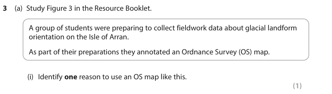
Q3(a)(ii)
The whole paper ↗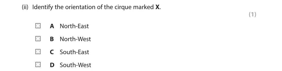
Q3(a)(iii)
The whole paper ↗
Q3(a)(iv)
The whole paper ↗
Q3(a)(v)
The whole paper ↗
Q3(b)
The whole paper ↗
Q2(a)
The whole paper ↗
Q2(b)
The whole paper ↗
Q2(a)
The whole paper ↗
Q2(c)
The whole paper ↗
Q2(d)
The whole paper ↗
Q2(c)
The whole paper ↗
Q2(d)
The whole paper ↗
Q3(a)(i)
The whole paper ↗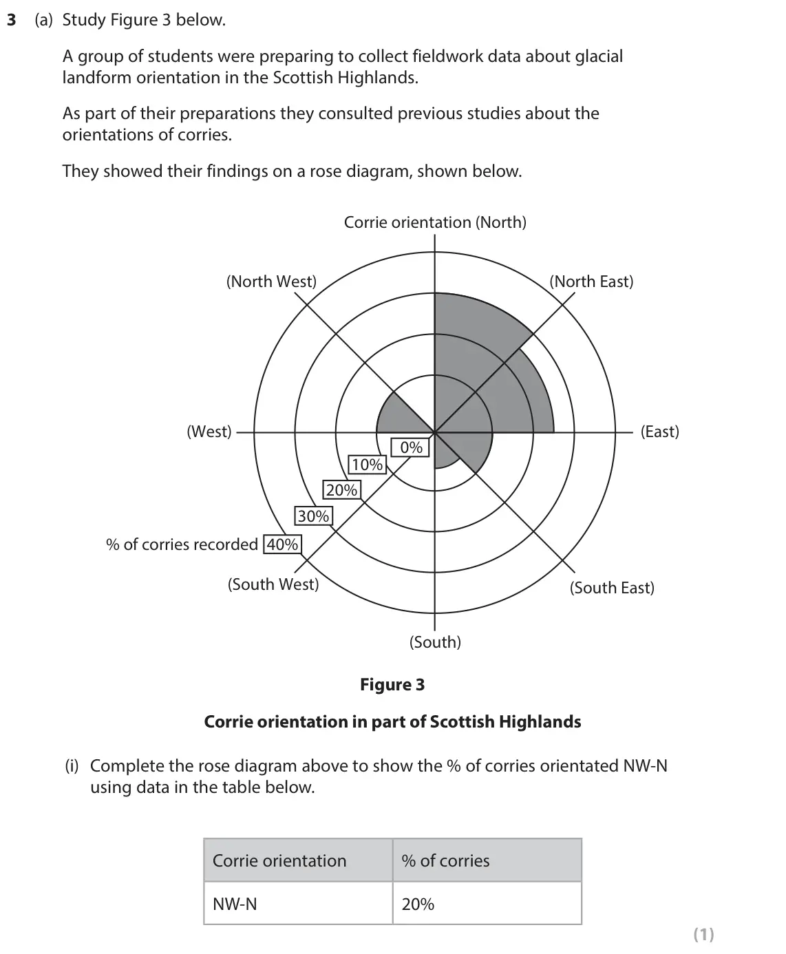
Q3(a)(ii)
The whole paper ↗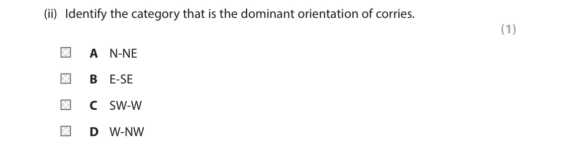
All 60 questions on How do glacial processes contribute to the formation of glacial landforms and landscapes?, as a list
- June 2025, Paper 1, Q2(a) (6 marks): Explain the role of valley glaciers in the formation of this landscape. (6) 2 Study Figure 2a in the Resource Booklet. SECTION B The following resources relate
- June 2025, Paper 1, Q2(b) (6 marks): Explain the influence of geology in the formation of this knock and lochan landscape. (6) 2 Study Figure 2a in the Resource Booklet. SECTION B The following res
- June 2025, Paper 1, Q2(c) (8 marks): Explain why meltwater creates distinctive depositional fluvio-glacial landforms. (8) 2 Study Figure 2a in the Resource Booklet. SECTION B The following resource
- June 2025, AS Paper 1, Q2(a) (1 mark): State one piece of evidence used to reconstruct former ice extent. (1) SECTION B The following resources relate to Questions 2–4. Glacier Annual rate of retreat
- June 2025, AS Paper 1, Q2(d) (6 marks): Explain how proglacial landforms are formed by glacial meltwater. (6) SECTION B The following resources relate to Questions 2–4. Glacier Annual rate of retreat
- June 2025, AS Paper 1, Q3(a)(i) (1 mark): Identify one reason to use an OS map like this. (1) Waterfall at Sannox 50m Cir Mhòr 799m X N Key Risk management: Recommended walking route 1km Start of walkin
- June 2025, AS Paper 1, Q3(a)(ii) (1 mark): Identify the orientation of the cirque marked X. (1) A North-East B North-West C South-East D South-West Waterfall at Sannox 50m Cir Mhòr 799m X N Key Risk mana
- June 2025, AS Paper 1, Q3(a)(iii) (1 mark): Calculate the difference in altitude between Waterfall at Sannox and Cir Mhòr. (1) Waterfall at Sannox 50m Cir Mhòr 799m X N Key Risk management: Recommended wa
- June 2025, AS Paper 1, Q3(a)(iv) (2 marks): Suggest one reason why the students should plan to use the recommended footpath up to Cir Mhòr. (2) Waterfall at Sannox 50m Cir Mhòr 799m X N Key Risk managemen
- June 2025, AS Paper 1, Q3(a)(v) (4 marks): Explain two ways students could use ICT. (4) Waterfall at Sannox 50m Cir Mhòr 799m X N Key Risk management: Recommended walking route 1km Start of walking route
- June 2025, AS Paper 1, Q3(b) (9 marks): You have carried out an investigation into glaciated landscapes and change. Assess the value of the data collection methods used in your primary fieldwork. (9)
- June 2024, Paper 1, Q2(a) (6 marks): Explain how the processes of lodgement and ablation have created this relict till plain. (6) 2 Study Figure 2a in the Resource Booklet. SECTION B The following
- June 2024, Paper 1, Q2(b) (6 marks): Suggest how glacial erosion has contributed to the formation of this landscape. (6) 2 Study Figure 2a in the Resource Booklet. SECTION B The following resources
- June 2024, AS Paper 1, Q2(a) (1 mark): Name one fluvioglacial landform. (1) SECTION B The following resources relate to Question 2 and 3. Diameter of stone polygon Figure 2b Patterned ground in Norwa
- June 2024, AS Paper 1, Q2(c) (4 marks): Explain two landforms that are created by valley glacier erosion. (4) SECTION B The following resources relate to Question 2 and 3. Diameter of stone polygon Fi
- June 2024, AS Paper 1, Q2(d) (6 marks): Explain how distinctive landforms are created by glacial deposition. (6) SECTION B The following resources relate to Question 2 and 3. Diameter of stone polygon
- June 2023, AS Paper 1, Q2(c) (6 marks): Explain how glacial deposition landforms can help reconstruct former ice extent and movement. (6) SECTION B The following resources relate to Question 2. N A Pe
- June 2023, AS Paper 1, Q2(d) (12 marks): Assess the contribution of glacial meltwater in the formation of glaciated landscapes. (12) SECTION B The following resources relate to Question 2. N A Penllyn
- June 2023, AS Paper 1, Q3(a)(i) (1 mark): Complete the rose diagram above to show the % of corries orientated NW-N using data in the table below. Corrie orientation % of corries NW-N 20% (1)
- June 2023, AS Paper 1, Q3(a)(ii) (1 mark): Identify the category that is the dominant orientation of corries. (1) A N-NE B E-SE C SW-W D W-NW
- June 2023, AS Paper 1, Q3(a)(iii) (1 mark): Identify the most suitable statistical technique to test if there is a significant difference between the observed and expected number of corries that are orien
- June 2023, AS Paper 1, Q3(a)(iv) (2 marks): Suggest a suitable hypothesis or key question that the students could investigate. (2)
- June 2023, AS Paper 1, Q3(a)(v) (4 marks): Explain two primary fieldwork methods that could be used to extend this investigation. (4)
- June 2023, AS Paper 1, Q3(b) (9 marks): You have carried out an investigation into glaciated landscapes and change. Assess the value of secondary data at different stages of your geographical investig
- June 2023, AS Paper 1, Q4 (16 marks): Study Figures 4a, 4b, 4c and 4d in the Resource Booklet. Evaluate the extent to which the distinctive landscape in the St Elias-Wrangell mountain range is cause
- June 2022, Paper 1, Q2(a) (6 marks): Explain the contribution of glacial processes to the development of these landforms. (6) 2 Study Figure 2a in the Resource Booklet. SECTION B The following reso
- June 2022, Paper 1, Q2(b) (6 marks): Explain how glacial deposition contributes to the development of this landscape. (6) 2 Study Figure 2a in the Resource Booklet. SECTION B The following resource
- June 2022, AS Paper 1, Q2(b)(ii) (3 marks): Suggest one reason for the pattern of glacial moraine in Figure 2. (3) SECTION B The following resources relate to Questions 2–3. Figure 2 Aerial photo of Mt Ba
- June 2022, AS Paper 1, Q2(e) (12 marks): Assess the extent to which the processes of deposition are more important than the processes of erosion in creating distinctive glacial landscapes. (12) SECTION
- June 2022, AS Paper 2, Q6(a) (1 mark): Identify one risk students might have had to consider when carrying out fieldwork in this environment. (1) 6 Study Figure 6 in the Resource Booklet. A group of
- June 2022, AS Paper 2, Q6(b) (1 mark): Calculate the % of sites where flowing water was observed. Give your answer to one decimal place. (1) 6 Study Figure 6 in the Resource Booklet. A group of stude
- June 2022, AS Paper 2, Q6(c) (1 mark): Identify the modal class for the sediment orientation. (1) 6 Study Figure 6 in the Resource Booklet. A group of students collected fieldwork data at 15 differen
- June 2022, AS Paper 2, Q6(d) (2 marks): The students concluded that the landscape was shaped by fluvioglacial processes. Suggest why the primary data in Figure 6 shows that the conclusion might be a s
- June 2022, AS Paper 2, Q6(e) (4 marks): Explain two ways the data collection methods could be improved. (4) 6 Study Figure 6 in the Resource Booklet. A group of students collected fieldwork data at 15
- November 2021, Paper 1, Q2(b) (6 marks): Explain the differences in the characteristics of the deposits at locations A and B. (6) 2 Study Figure 2a in the Resource Booklet. SECTION B The following reso
- October 2020, Paper 1, Q2(c) (8 marks): Explain how upland glacial landforms can be used to study former ice extent and movement. (8) 2 Study Figure 2a in the Resource Booklet. SECTION B The following
- October 2020, AS Paper 1, Q3(a)(ii) (1 mark): Study Figure 3. Identify the type of glaciated landform shown in box A (Loch Brandy). (1) Box A Box A Loch Brandy N 0 1km Key Slope angle Extremely high / steep
- October 2020, AS Paper 1, Q3(a)(iii) (3 marks): Describe the angle of slope the students might expect to find around Loch Brandy. (3) Box A Box A Loch Brandy N 0 1km Key Slope angle Extremely high / steep Roa
- October 2020, AS Paper 1, Q3(a)(iv) (4 marks): Explain two decisions these students would have to make as part of a risk assessment. (4) Box A Box A Loch Brandy N 0 1km Key Slope angle Extremely high / steep
- October 2020, AS Paper 1, Q3(b) (9 marks): You have carried out primary fieldwork to investigate glacial landscapes and change. Assess the effectiveness of the techniques you used to present and analyse
- June 2019, Paper 1, Q2(a) (6 marks): Explain the contribution of glacial erosional processes to the development of this landscape. (6) 2 Study Figure 2a in the Resource Booklet. SECTION B The follo
- June 2019, Paper 1, Q2(b) (6 marks): Explain the contribution of glacial deposition to the development of this landscape. (6) 2 Study Figure 2a in the Resource Booklet. SECTION B The following reso
- June 2019, AS Paper 1, Q2(d) (4 marks): Explain two processes of water movement within glaciers. (4) SECTION B The following resources relate to Questions 2–4. Figure 2b An avalanche in the French Alp
- June 2019, AS Paper 1, Q2(e) (6 marks): Explain how the characteristics of glacial and fluvioglacial deposits differ. (6) SECTION B The following resources relate to Questions 2–4. Figure 2b An avalan
- June 2019, AS Paper 1, Q3(a)(i) (1 mark): State one reason for studying cirque/corrie orientation. (1)
- June 2019, AS Paper 1, Q3(a)(ii) (1 mark): Complete the table above by calculating the missing number in the Orientation 180° – 269° column. (1)
- June 2019, AS Paper 1, Q3(a)(iii) (1 mark): Calculate the value of Chi2 (X2) from the data given. (1)
- June 2019, AS Paper 1, Q3(a)(iv) (2 marks): Suggest one reason for carrying out a Chi2 (X2) test on this data set. (2)
- June 2019, AS Paper 1, Q3(a)(v) (4 marks): Explain two primary fieldwork methods that might have been used to extend this investigation on ice flow direction. (4)
- June 2019, AS Paper 1, Q3(b) (9 marks): You have carried out primary fieldwork to investigate glacial landscapes and change. Assess how the sampling procedures and sample size affected your results. (
- June 2018, Paper 1, Q2(c) (8 marks): Explain the role of glacial meltwater in creating distinctive landforms. (8) 2 Study Figure 2a in the Resource Booklet. SECTION B The following resources relate
- June 2018, AS Paper 1, Q2(a) (1 mark): State one process of mass movement that occurs in glaciated landscapes. (1) SECTION B The following resources relate to Questions 2-4. 15 Past Predicted 10 5 0
- June 2018, AS Paper 1, Q4 (16 marks): Study Figures 4a, 4b, 4c and 4d in the Resource Booklet. Evaluate the importance of tectonic processes and weather conditions in creating distinctive glacial la
- June 2017, AS Paper 1, Q2(c) (4 marks): Explain two processes of glacial erosion. (4) SECTION B The following resources relate to Questions 2–4. Nearer surface Nearer base (metres/year) (metres/year)
- June 2017, AS Paper 1, Q2(d) (6 marks): Explain the factors that create a lowland depositional landscape. (6) SECTION B The following resources relate to Questions 2–4. Nearer surface Nearer base (met
- June 2017, AS Paper 1, Q3(a)(i) (1 mark): Complete Figure 3a below by adding the following data for the Upper layer. (1) Clast Size (cm) Number recorded 5.1–7.5 cm 11 15.1–17.5 cm 20 60 50 40 30 20 10 0
- June 2017, AS Paper 1, Q3(a)(ii) (2 marks): The student decided to use a stratified sampling approach to collect their data. State two reasons why this could be an appropriate approach. (2) Upper layer Mi
- June 2017, AS Paper 1, Q3(a)(iii) (2 marks): Suggest one reason why the clast size in the Upper layer is different to that in the Middle layer. (2) Upper layer Middle layer Lower layer Figure 3 Photo of gl
- June 2017, AS Paper 1, Q3(a)(iv) (4 marks): The student collected this data to investigate the differences between glacial sediment. Explain two other techniques the student could have used as part of the
- June 2017, AS Paper 1, Q3(b) (9 marks): You have carried out secondary research to investigate glacial landscapes and change. Assess the value of secondary research in undertaking your geographical in
Questions, mark schemes and examiner’s reports are © Pearson Edexcel, from their published past papers. Plumi isn’t affiliated with any exam board. Want whole papers? Full past papers.
Rather write your answers by hand on iPad? Plumi marks them against the same mark schemes.